Yep, both Niklas and I stepped into the cold, cold city of Berlin for the first time on our first week in Europe, after the butt-numbing 7.5-hour bus and ferry ride from Copenhagen.
Following the instructions from our half-Pinay, half-German CouchSurfing host Analie, we took the “Messe/ICC” Ringbahn (loop train) to Gesundbrunnen (one of the main stations for the Ringbahn, S-bahn (railway train like MRT), U-bahn (metro/subway) and regional/international trains) and took the S-Bahn to where she lives. (So much “bahn” right? And we’re not talking about the buses and trams yet. While the transport system is quite efficient, one of the first few lessons in Berlin is that Bahn = train and going to one station using the right S-Bahn or U-Bahn requires tourists (and locals) to never underestimate the travel time necessary. haha)
Berlin commuter rail network from BerlinMap360 — see what I mean?!
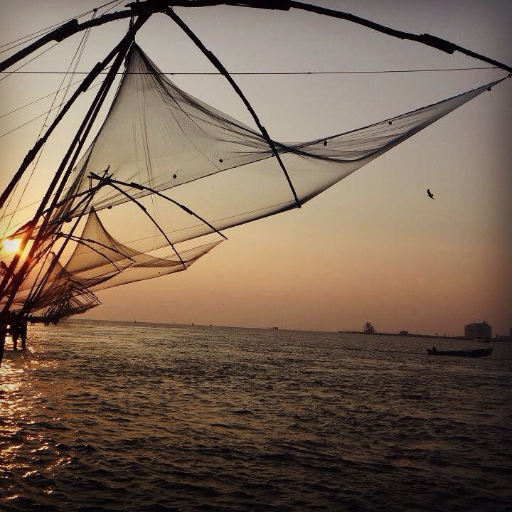
Before traveling to anywhere, I always research first for the top 3 things to see, do or eat — and my final tourist travel in the Indian sub-continent to Kerala and south India was no exemption. It’s like my non-negotiable. It doesn’t matter whether I’m staying 6 hours or 6 days — I must be able to see/do/eat the top 3 things. After that, I feel happy and accomplished, ready to move on to the next destination. So, when I was checking out things to do in Kochi, the first European colony in India and one of the major metropolitan cities of the south Indian state of Kerala, the Chinese Fishing Nets definitely was on the list. Called Cheena vala in Malyalam (the local language), the Chinese Fishing Nets at Vasco da Gama square in Fort Kochi is a popular tourist spot, especially at sunset. The silhouette of the Cheena vala lining up the shore is such a sight that you wouldn’t imagine it for its actual purpose — a fishing net!
During the first time I set foot in Malaysia back in 2010, we only had one day and between Melaka, Genting Highlands and the Batu Caves, we decided to play with the clouds. It was only during the month-long Southeast Asia backpacking trip that I made it to Melaka and to the Batu Caves, both thanks to my fried Rajie who took time off her busy schedule to tour me, Lalai and Tetet! 🙂 Anyway, Batu Caves, as the name suggests (in Tagalog, batu, well bato, means stone), is a series of caves and cave temples inside a limestone hill. Batu Caves is a popular tourist spot and Hindu temple site around 13kms north of Kuala Lumpur, the capital city of Malaysia. The area is surrounded by birds feeding on corn kernels the visitors throw around and by a small pond of ducks and koi fish. You’d need to climb up about 8-10 floors worth of stairs, alongside monkeys that can be pretty violent when they see food, to get inside the caves and the temples. Rajie, at the time at least, was not a devout Hindu so we were not sure whether the stories of Kartikeya (the massive golden statue at the foot of the caves to which the cave temples are dedicated to), and his family (daddy = Shiva, mommy = Parvati, brother = Ganapathi) and the peacock he’s riding, were as accurate as the scripts or just made up bedtime stories! It was quite entertaining though. 🙂 After visiting the caves, you might want to relax your legs and knees a bit and stay a while by the small pond, watching the ducks and koi fish glide and swim. Or, you can also pay a visit to Lord Hanuman, the monkey god, farther on the left.
I haven’t posted a new travel entry for two months now and as I am running out of excuses for it, I’ve decided to have a quick Instagram post of my 4-day trip to Visayas with Leah, my good friend whom I’ve met through CouchSurfing in India.
At the back of the speeding taxi from Kharghar to the Mumbai International Airport
As she’s only here for 8 days and I have just started on a new job, we made sure that she’d be able to see the Philippines under the urban/metro and rural/nature sense.
View of the west side of Bonifacio Global City from one of the office windows
Our first stop after she roamed the streets of Taguig, Makati and Manila is the naturally-gifted province of Bohol. While planning her trip, I asked Leah which of the 7107 islands of he Philippines would she be more interested in. I provided her with the top tourist destinations’ main selling points and at the mention of Tarsier, the world’s smallest primate (or so we thought), our itinerary finally had its anchor.
Up-Down from Left: Nap time while waiting for our 4AM flight via ZestAir, Terminal 4; ferry trip from Cebu to Bohol via 2Go; Bus toploaders galore; Bus topload view of Bohol (Sikatuna area); Loboc River Cruisers; Bell/Time Tower at Loboc Plaza; Loboc Church
I realized that during my “Bicolandia Exploration”, my first solo backpacking trip in the Philippines in late March 2011, I have taken several photos of the majestic Mayon Volcano (Mt. Mayon) at different angles and locations.
Of course, the first photos of Mt. Mayon that I took were at the famed Cagsaua Ruins.
Mayon Volcano and Cagsawa Ruins
On that day, the majestic Mayon decided not to show herself to me. No matter how much I pleaded.
It was a cloudy day and Mayon shied away!
I don’t know if you’ve heard of this myth or folklore that the Mayon only shows herself to people she likes. Of course, my Japanese boss will not hear of it but hey, that’s what people believe in!
Paddy fields at the foot of the volcano. I wonder how the rice grow with the quality of the soil…hmmm
My first encounter with Mt. Mayon was in Grade 6 (long time ago!) as part of a field-trip-cum-retreat at Acquinas University, a Diocesan school, in Legazpi. I could still remembered how I fumbled with the instamatic film camera when sitting out in the soccer/football field, “she showed herself” to us!
Mayon Volcano from the Lignon Hill viewing deck
So, you could probably just imagine my frustration when, even after climbing Lignon Hill, Mt. Mayon still hid from me! Ugh.
trying to be creative
I mean, WHY?! It was a bright sunny day. No threat whatsoever of raining. Or typhoons. And yet, the Mayon volcano still wouldn’t let me behold her in her full majesty!
Photo taken while ziplining (flying fox) at Lignon Hill. Warning: Kids, only “professional buwis-buhay travelers” can do this. Do not try at home!
Neither did she reveal her beauty while I went ziplining at Lignon Hill nor when I did a short trek at the lava flow/ash floored area. Even with the effort!!!
Getting nearer but not clearer at the lava flow/ash trek area
I know, I probably sound like a disgruntled customer right now but when you have a DSLR and a digital camera in place of a slow and manual film one, you kinda hope for the best shot possible!
It was only after four days, when I was heading back to Legazpi from a great beach time in Tikling Island at Matnog, Sorsogon that Mayon decided to show up! And I was on a moving bus!!!
I had to suddenly move to the back of the bus to take this shot of the Mayon! Effort!
I mean, cmon! The bus was moving and I didn’t know yet how long it will take until we stop at the terminal. Or if Mt. Mayon would still be clear and “picture-perfect” by that time! So, hard as it was, I snapped away without thinking much about composition, lighting, creatives, etc.! That was the moment and I had to capture it!
Mt. Mayon’s crater used to be of a perfect cone shape. Even with a little deformation, it’s still beautiful! The “steam” looks hot and dangerous though!
I even managed to take a photo of the crater, once said to have been perfect—which is also why Mt. Mayon, an active volcano, is among the most famous in the Philippines and the Pacific Ring of Fire.
Waiting at the terminal for your ride while reveling at Mt. Mayon isn’t so bad, is it?!
Luckily, when I got off at the central bus and shuttle van terminal in Legazpi, she was still waiting for me to get my shot—and have it done right! Capturing the different images of Mayon volcano and seeing it from different angles was definitely one of the highlights of my first backpacking trip!
Life is short so take a leap of faith. Let’s wander, explore and discover. Come and journey with me.