Images

#100Days Photo 31: Cheena vala, Fort Kochi Beach, Kerala, South India

IMG_2518.JPG

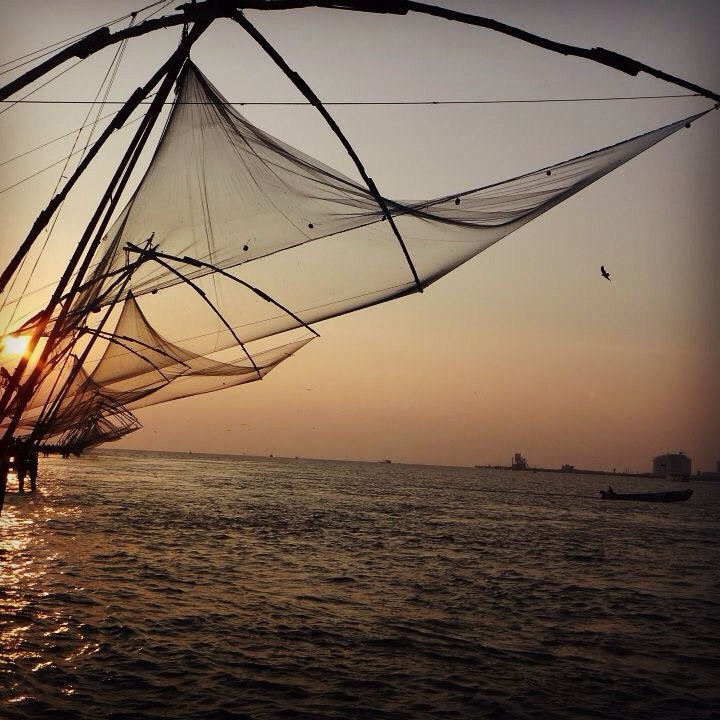
Before traveling to anywhere, I always research first for the top 3 things to see, do or eat — and my final tourist travel in the Indian sub-continent to Kerala  and south India was no exemption. It’s like my non-negotiable. It doesn’t matter whether I’m staying 6 hours or 6 days — I must be able to see/do/eat the top 3 things. After that, I feel happy and accomplished, ready to move on to the next destination. So, when I was checking out things to do in Kochi, the first European colony in India and one of the major metropolitan cities of the south Indian state of Kerala, the Chinese Fishing Nets definitely was on the list. Called Cheena vala in Malyalam (the local language), the Chinese Fishing Nets at Vasco da Gama square in Fort Kochi is a popular tourist spot, especially at sunset. The silhouette of the Cheena vala lining up the shore is such a sight that you wouldn’t imagine it for its actual purpose — a fishing net!

#100Days Photo 29: The Small Pond and the Batu Caves, Selangor, Malaysia

IMG_2383.JPG
During the first time I set foot in Malaysia back in 2010, we only had one day and between Melaka, Genting Highlands and the Batu Caves, we decided to play with the clouds. It was only during the month-long Southeast Asia backpacking trip that I made it to Melaka and to the Batu Caves, both thanks to my fried Rajie who took time off her busy schedule to tour me, Lalai and Tetet! 🙂 Anyway, Batu Caves, as the name suggests (in Tagalog, batu, well bato, means stone), is a series of caves and cave temples inside a limestone hill. Batu Caves is a popular tourist spot and Hindu temple site around 13kms north of Kuala Lumpur, the capital city of Malaysia. The area is surrounded by birds feeding on corn kernels the visitors throw around and by a small pond of ducks and koi fish. You’d need to climb up about 8-10 floors worth of stairs, alongside monkeys that can be pretty violent when they see food, to get inside the caves and the temples. Rajie, at the time at least, was not a devout Hindu so we were not sure whether the stories of Kartikeya (the massive golden statue at the foot of the caves to which the cave temples are dedicated to), and his family (daddy = Shiva, mommy = Parvati, brother = Ganapathi) and the peacock he’s riding, were as accurate as the scripts or just made up bedtime stories! It was quite entertaining though. 🙂 After visiting the caves, you might want to relax your legs and knees a bit and stay a while by the small pond, watching the ducks and koi fish glide and swim. Or, you can also pay a visit to Lord Hanuman, the monkey god, farther on the left.

#100Days Photo 28: Chao Phraya River and the Bhumibol Bridge, Bangkok, Thailand

IMG_2370.JPG

The Me Nam Chao Phraya is a major river in Thailand, even referred to as the River of Kings. On my second day in Bangkok, during my Rattanakosin Island walkabout, I ended up in a plaza across Wat Arun (Temple of the Dawn) where the Chao Phraya river has overflowed, swallowing most of the benches by the riverbanks. If you remember the flooding in Bangkok and Thailand in October 2011, you wouldn’t think that the overflow from the calm Chao Phraya River can be the cause for severe flooding in many of the provinces and its capital city. This photo, taken the next day when I explored Bangkok outside of Rattanakosin, was when I took the Chao Phraya Express Boat so I can have a closer look at some of the sights I have missed! Also coz I’m so cheap to buy the dinner river cruise ticket. Hehe 🙂 We passed under the towering Industrial Ring Road Bridge or officially, the Bhumibol Bridge, named after King Bhumibol Adulyadej (apparently, naming bridges after Kings is customary). By the time I left Bangkok the day after, the city was already frantic trying to prepare for the floods — communities passing and arranging sandbags, construction of 2-feet cemented walls by their homes’ doors, diversion of traffic in some areas. Although the Chao Phraya River caused misery to many Thai people, the River of Kings remain to be an important part of their daily lives — either for agriculture, trade or transport. I hope measures, by government and the communities, are being taken so that the October flooding won’t happen to Bangkok or to Thailand again.

#100Days Photo 27: Bomod-ok Falls aka The Big Falls of Sagada

Bomod-ok

A few nights ago, some friends and I were talking about Sagada since some of them are planning to go. Of course, one of the top recommendations I can give them is to pay a visit to the Bomod-ok Falls, also known as the Big Falls. How big? Well, it stands 200ft high and at the time of our visit (March), water was really, errr, falling! Bomod-ok Falls, located about 30-minutes on a jeepney or van, is nestled at North Sagada, deep into the rice paddy terraces. How deep? Say an hour’s trek going down from the road to the falls, walking along the rice paddies, passing by villages and stream, and another hour going back up on the other way. Was it worth all the calories burnt? Definitely! If I am to visit Sagada again, I would still pay the Big Falls a visit, observe the villages and rice terraces we will pass by, chill at the secret pool on the left side of the falls (you’d have to do a duck walk or crawl through the gap to get there), brave the almost-90-degrees-buwis-buhay-rocks to go “cliff-diving” on the right side, swim till I can’t feel my toes, and just we awed by Bomod-ok Falls and its majesty.

#100Days Photo 26: Sunrise over Sunset at Long Beach, Bauang, La Union

IMG_1607.JPG

Since it’s been a while since I posted photo 26 on my instagram account, it took me some time to re-figure out that this photo was taken while staying at Long Beach Resort Hotel in Bauang, La Union. As one of the many coastlines of northwestern Philippines, Bauang is known for its spectacular sunsets. This photo, however, was taken at sunrise and it has taken me by surprise! And yes, I woke up super early coz that was the only way I’d get some R&R time as this trip was actually official! 🙂 I didn’t realize it could be a really nice view as well, with the super calm waters and the fiery hue of the sky! And no, I didn’t use any digital imaging with this photo since, at the time it was taken in mid-2009, hashtags aren’t even born yet and #nofilter more so! So this is just plain ‘ol Bauang sunrise and natural goodness for y’all!