The Me Nam Chao Phraya is a major river in Thailand, even referred to as the River of Kings. On my second day in Bangkok, during my Rattanakosin Island walkabout, I ended up in a plaza across Wat Arun (Temple of the Dawn) where the Chao Phraya river has overflowed, swallowing most of the benches by the riverbanks. If you remember the flooding in Bangkok and Thailand in October 2011, you wouldn’t think that the overflow from the calm Chao Phraya River can be the cause for severe flooding in many of the provinces and its capital city. This photo, taken the next day when I explored Bangkok outside of Rattanakosin, was when I took the Chao Phraya Express Boat so I can have a closer look at some of the sights I have missed! Also coz I’m so cheap to buy the dinner river cruise ticket. Hehe 🙂 We passed under the towering Industrial Ring Road Bridge or officially, the Bhumibol Bridge, named after King Bhumibol Adulyadej (apparently, naming bridges after Kings is customary). By the time I left Bangkok the day after, the city was already frantic trying to prepare for the floods — communities passing and arranging sandbags, construction of 2-feet cemented walls by their homes’ doors, diversion of traffic in some areas. Although the Chao Phraya River caused misery to many Thai people, the River of Kings remain to be an important part of their daily lives — either for agriculture, trade or transport. I hope measures, by government and the communities, are being taken so that the October flooding won’t happen to Bangkok or to Thailand again.
A few nights ago, some friends and I were talking about Sagada since some of them are planning to go. Of course, one of the top recommendations I can give them is to pay a visit to the Bomod-ok Falls, also known as the Big Falls. How big? Well, it stands 200ft high and at the time of our visit (March), water was really, errr, falling! Bomod-ok Falls, located about 30-minutes on a jeepney or van, is nestled at North Sagada, deep into the rice paddy terraces. How deep? Say an hour’s trek going down from the road to the falls, walking along the rice paddies, passing by villages and stream, and another hour going back up on the other way. Was it worth all the calories burnt? Definitely! If I am to visit Sagada again, I would still pay the Big Falls a visit, observe the villages and rice terraces we will pass by, chill at the secret pool on the left side of the falls (you’d have to do a duck walk or crawl through the gap to get there), brave the almost-90-degrees-buwis-buhay-rocks to go “cliff-diving” on the right side, swim till I can’t feel my toes, and just we awed by Bomod-ok Falls and its majesty.
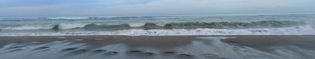
Since it’s been a while since I posted photo 26 on my instagram account, it took me some time to re-figure out that this photo was taken while staying at Long Beach Resort Hotel in Bauang, La Union. As one of the many coastlines of northwestern Philippines, Bauang is known for its spectacular sunsets. This photo, however, was taken at sunrise and it has taken me by surprise! And yes, I woke up super early coz that was the only way I’d get some R&R time as this trip was actually official! 🙂 I didn’t realize it could be a really nice view as well, with the super calm waters and the fiery hue of the sky! And no, I didn’t use any digital imaging with this photo since, at the time it was taken in mid-2009, hashtags aren’t even born yet and #nofilter more so! So this is just plain ‘ol Bauang sunrise and natural goodness for y’all!
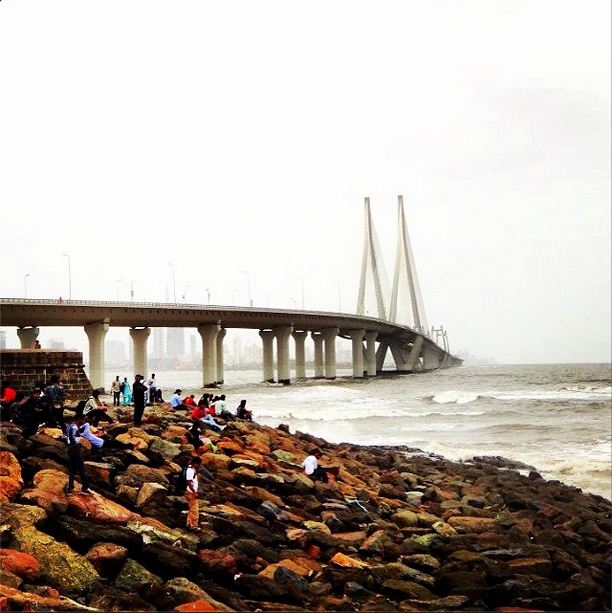
Located at Land’s End in Bandra, this area kissing Mahim Bay and overlooking the Bandra-Worli Sea Link is a favorite spot among young Mumbaikaars, families and tourists. Further from the rocky shore, it was really fun playing with the strong waves of Mahim Bay, praying that we don’t get washed away! (ah, memories!) At the end of the kilometer-long Bandstand Promenade, you will find Bandra Fort (also known as Castella de Aguada or Fort of the Waterpoint). While the remains of the castle/fort no longer serves the purpose it was built for by the Portuguese before, it still serves as a viewpoint for the entire Mahim Bay and the Arabian Sea. From here, you can see the towering glory of the 5.6km-long Bandra-Worli Sea Link. Constructed to ease traffic congestion, the Rajiv Gandhi Sea Link (official name) connects Bandra in the Western Suburbs and Worli in South Mumbai.
As I’ve mentioned before, it takes a lot of willpower and natural beauty for me to be dragged out of bed at sunrise. Luckily, the scenery in Bolinao is one such wonder that I was able to force myself to step out of my room (I had to anyway coz it’s early work day for farmers’ training) at El Pescador Resort and watch the fishermen go about their business. The water was calm, except for the ripples from a fisherman’s small boat and nets being cast in the sea. It was said that before becoming a hotel and resort by the sea, El Pescador used to be a small fishing village, benefiting from the rich marine life of Bolinao in Pangasinan. It’s not exactly a swimming beach, especially with some kind of seawall separating the waters from the resort area. It is, however, still a nice sight to behold in the morning. I wonder how El Pescador sunset looks like, since Bolinao and Pangasinan generally belong to the sunset magic hour area. (Photo taken 08/31/2010)
Life is short so take a leap of faith. Let’s wander, explore and discover. Come and journey with me.